
|
|
After 40 hours of storm chasing during April and a lot of time, fuel, and expenses exhausted chasing weather in the south of the country it didn't long before I was out again on the hunt for photogenic weather and for that I was truly thankful. May arrived with warmer temps and more unstable weather for a bizarre range of directions varying from NEly to Wly and then to a NWly with no sign of the classic action-producing SWly which has always been my favourite direction and a reliable source for the best Summer storms in this country. Unstable air coming from less common directions forces one to think different and target different parts of the country often forcing you more S than usual to get in a position where convection can cover enough land mass to build into a storm, this differs from the SWly set-up where storms fire then head NE with plenty of warning so you can intercept them as they near. May 6th was the first organised risk of the year for N. Ireland with enough speed shear to tilt any updraughts over causing a separation between inflow and outflow allowing cells to become organised with a longer life span with a greater chance of a locally severe weather event happening. The predicted low cloud bases and atmospheric environment were favourable for tornadoes and across the water in England supercell thunderstorms were a possibility. It was an exciting forecast however the day would be messy and the greatest concern was over surface heating for if the sky did not clear then the sun could not heat the ground and that would be the loss of the primary trigger/lifting mechanism for firing proper convection.
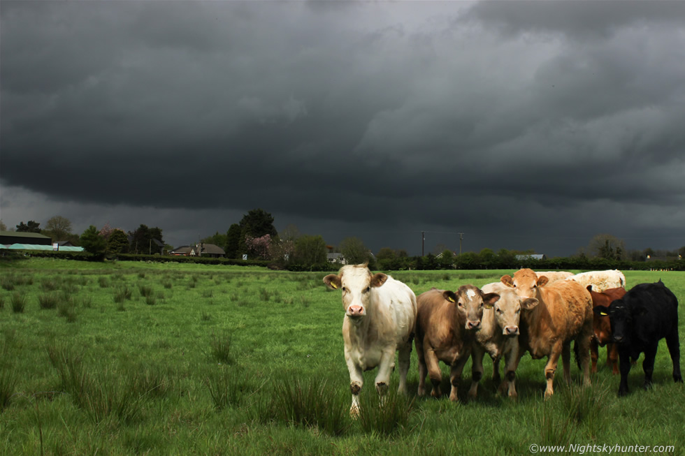 |
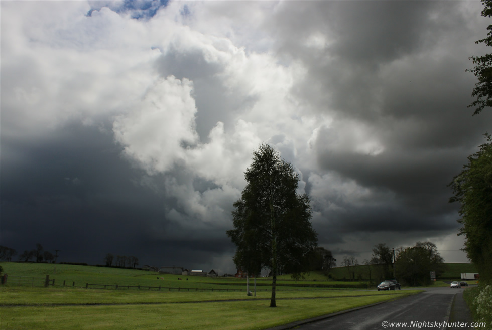
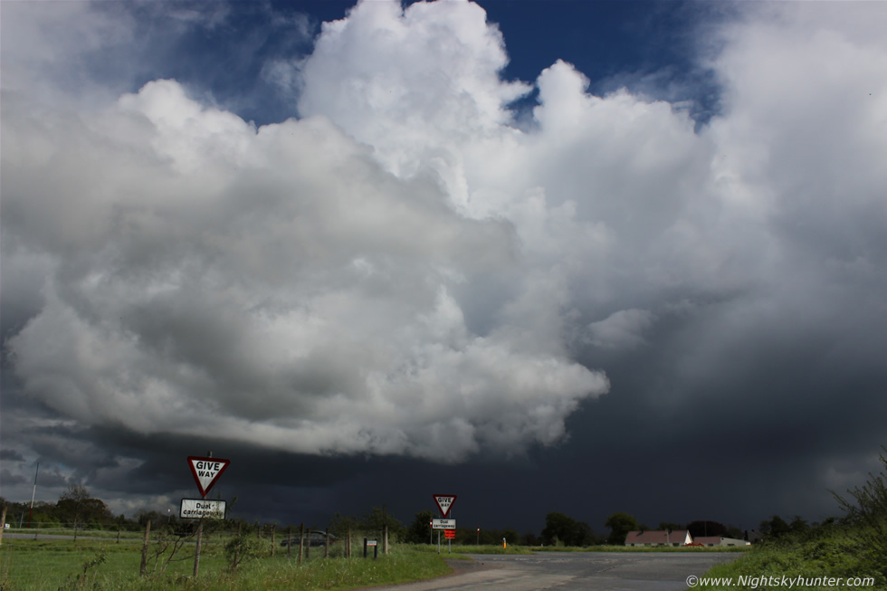
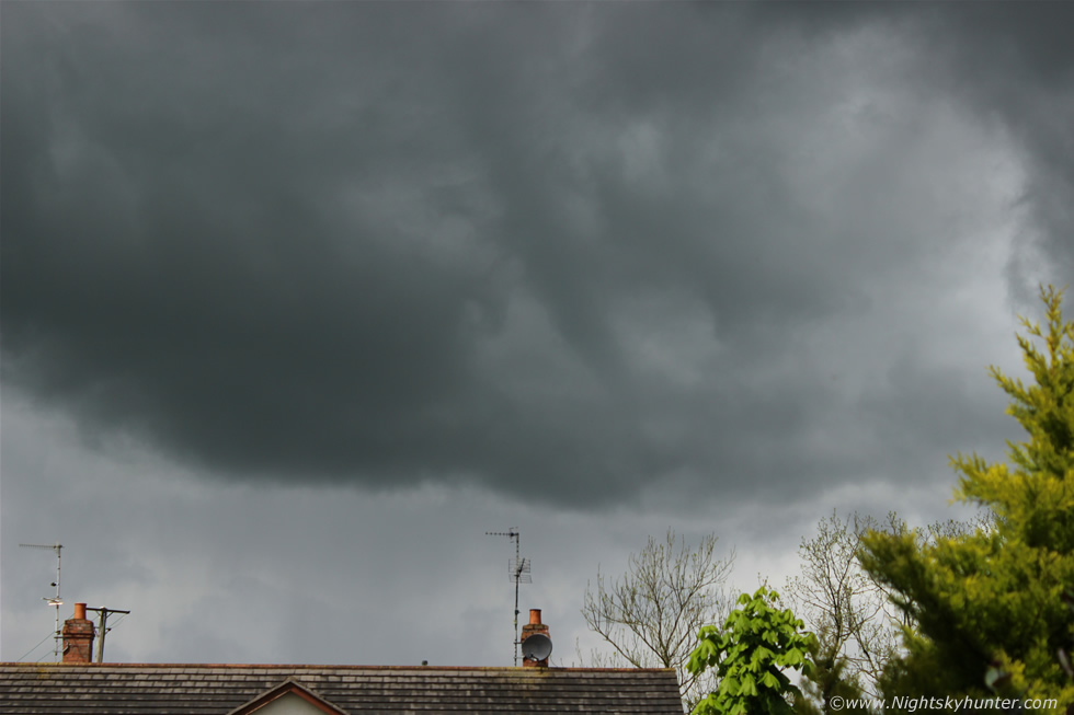
By early afternoon things were looking promising in my home area of Maghera as the cloud thinned and broke allowing short episodes of sun to break through and the effects on the clouds were immediate. Soon the flat skies gave way to chunky elements then towers and young cells began to grow, it actually felt very warm and humid and that everything was falling into place perfectly. A nasty extremely low level base passed over the Sperrins and was moving in over the adjacent fields close to my house so I 'chased' after it on foot by literally walking to the bottom of the road with a good view across the countryside, this was facing N with the black cell base moving from L to R with precip breaking out, it looked like the clouds were about to burst. The cows in this field took a great interest in what I was doing, perhaps they thought I was taking images of them and not the clouds, the light was fantastic with the sun beaming down overhead turning the field and cows into vibrant colours which made for a nice photo opportunity.
The cows decided to check me out and walked over to investigate, they were very friendly and of good nature and seemed to pose for my images, I even took a little video clip of this scene as it looked very dramatic. At one stage the most curious member of the herd stuck his nose through a gap in the wire fence and began sniffing my camera lens, I was thinking at the time that this would have been an ideal scene had there been a funnel cloud hanging from that base, foreground and light like this doesn't happen too often that's for sure. Soon after this a cell passed over Maghera with a nice gust front and subtle whale's mouth delivering a very heavy shower with hail stones and once it passed all interesting aspects of the clouds seemed to pass with it, the core intensified once it crossed the NE side of Lough Neagh then it hit Antrim but there were never any sferics recorded.
It stayed cloudy for the rest of the afternoon and I began to get concerned as it was looking dull and cool which did not aid air mass thunderstorm formation, I was desperate to get after something and spotted a narrow line of radar heading up over Lough Neagh making a beeline for the Antrim side of the Lough so I drove S to intercept it, while on the back roads I observed very dramatic black clouds which were worthy of shooting however I couldn't find a place to pull over and once I did find one in the country the view was obscured by hills and tall electric pylons so I let it go and moved on to Ballyronan Marina on the NW side of the Lough. When the line arrived it was a complete mess of grey featureless cloud and persistent rain, I waited and waited for it to pass in case there was something photogenic at the rear however there was nothing, the sky just stopped raining and remained cloudy, this was already late afternoon so I considered the day a bust and drove back home unhappy, those images of the clouds and cows were the most photogenic rewards I had got from this day.
A big surprise came at 20.00 when I heard thunder, I checked radar and saw a large showery complex moving pass Maghera to the E with intense red reflectivity which had shocked me, where had that come from?, getting storms this late in the evening is not a common thing here, I watched from my bedroom window and heard multiple rumbles of thunder and witnessed two flashes of lightning to my E so I began taking video with my 600D and caught a bright in-cloud bolt on the footage which was cool. I jumped into the car and drove into the country in pursuit however when I had stopped the lightning was gone and yet again the sky was grey and overcast, the storm was high based and high precipitation (HP) in nature so there was no structure to see and photograph at all, this was very frustrating however it was great to hear thunder from home which always makes me smile, I felt momentarily satisfied however I was craving more, those rumbles were teasing me.
 |
May 13th provided me with another chance of pursuing convective storms and this time it was on a Saturday so my girlfriend Roisin accompanied me for a day's chasing and thankfully the models were hinting at possible activity closer to home which made for a much welcomed change from the long hours spent driving last month. CAPE values were widespread between 800-1000 with LIs -2 to -3 in a Wly veering to NWly unstable flow behind an active cold front which had crossed the country the previous night producing intense rainfall with the strongest large scale radar signatures over Ireland I have seen this year, the front produced lightning over Sligo and radar hinted at a rotation event in the southern midlands so I stayed up extra late on Friday night to watch just incase there was action, well it was a damp squib with no sparks over N.I however listening to the heavy rain outside the open window while I lay in bed was a very relaxing melody to drift off to sleep in.
I was up at 07.00 on Saturday morning and the sun was shinning and it was already warm and sunny which made me happy. By 09.00 convection was bubbling up nicely and the first cell of the day formed to the E of Maghera before collapsing but seeing something that early was a good sign. There was no speed shear this day so storms would be of the garden variety pop corn type or pulse storms which meant we needed to get on them as soon as they formed or even better - before the cell's matured, the positive side was that they where slow moving so we could get on them and follow any cell easily enough given a good road network. I got the gear ready, filled flasks, and checked the morning model run while chatting with other chasers on facebook about the potential. The Met Office had released a yellow warning for heavy showers and thunderstorms with risk of flooding so it was good to get them onboard. My personal prediction for this chase was anywhere in the Lough Neagh, Sperrins, Armagh and Down areas because the flow would be blowing cells into those areas by evening however the CAPE was also good near the border and Fermanagh too. My plan was to simply head S, but not too far S, to the Omagh road and watch development and check radar which was a good central point then we had the option of going N to the Lough or Sperrins or S into Kesh if we needed too.
Roisin and I did some local messages in Maghera and got sandwiches made up while the rain was pouring in the town then we headed S passing through the first band of showers then when on the N side of Cookstown we passed the second band then we entered dry air and the sun was warm and pleasant with towers starting to go up in the S. Once we arrived in Cookstown a cell formed and began to move N so we let it go and continued through the town only to find the town centre closed due to the continental market so we had to turn and work our way around the outskirts of the town and eventually made it onto the Omagh road where the sun was warm and convection was firing everywhere, in the rear view I saw that earlier cell now over the Sperrins towards my home and it looked good enough to stop and get out for a look, two big towers were erupting in that direction with a good deep low level base and I began to wonder if heading any further S was a bad idea so we stayed on this road then found a local restaurant where we could get wifi access. After a hastily devoured latte I got online via the lap top and was delighted that the models had upgraded the CAPE in the 900-1000 range which was much more widespread and the models were predicting convective precip over the Sperrins and Lough Neagh area yet again which confirmed our visual slighting of the Sperrins cell earlier supporting this new information, furthermore Tony Gilbert from UKweatherworld upgraded his forecast with a box surrounding the Lough Neagh basin where the strongest storms could break out so we decided to shift back N.
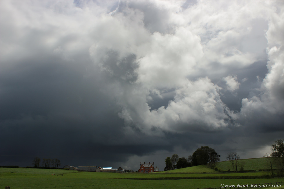
Driving rapidly back N on the Omagh road we could see cells forming everywhere and a good one with anvil to the N so it looked like things were happening, once back in Cookstown we stopped off at ASDA so Roisin could get a few things from the shop while I waited in the car watching the sky not wanting to miss a second incase a funnel formed. During the half hour or so I was there I began to get worried that something was wrong with the sky, the clouds were not getting high and seemed soft on top and I feared that this day was going to be a bust however once Roisin arrived we were back on the move but got caught up in very slow moving traffic jams in Cookstown which was extremely frustrating. My attitude changed once I looked in the wing mirror and saw black clouds approaching us from behind which looked very menacing and at once I knew a storm had formed, we got out from the busy traffic and went after the cell and once on the N side of Cookstown we pulled over into a lay by and got out to get images. This is the storm cell in the process of leaving Cookstown and moving E towards Lough Neagh where it would soon put down a cluster of c-g bolts along the NW side of the Lough, moving R to L on the image with black base/precip core with tower building on the back edge, I liked the distant house and farm on the adjacent fields which provided a great sense of scale for the storm.
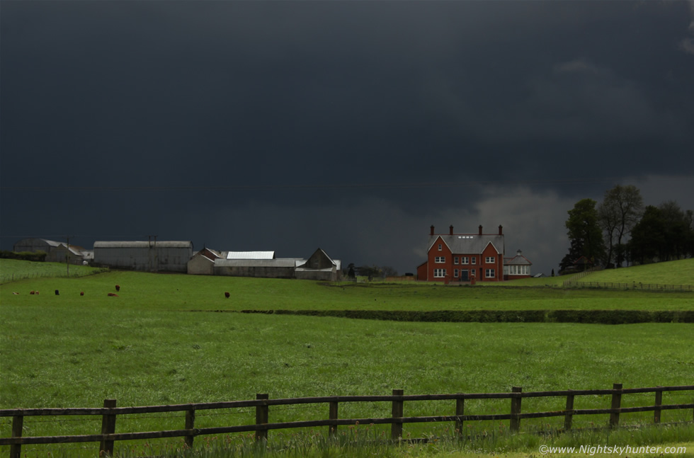 |
The light was fantastic with black thundery skies while the sun shone on the lush fields, it would have been so cool to have had a funnel hanging over that barn. I was standing near the carriageway going into Cookstown with a lot of traffic rushing past me so I had to take quite a few shots before I got one without a car or lorry in the frame. I glanced behind me and saw Roisin doing a great job filming the clouds and me for a video blog which was something we had been doing on and off all day since the previous night to document this chase for a little fun. For the second time this day someone beeped their horn at me as if saying hello, first a lorry then a car, did they know me?, I have no idea but they definitely knew I was shooting storm clouds, perhaps the subject has now become so popular in this country that people are now much more familiar with the weather and desensitized to seeing cameras pointing skyward, just shows how much things have changed from years ago, great to see it!
 |
I ran across the grass verge and back to the car in the lay by and got a few images and video clips of the storm as it crossed the fields which looked quite cool against these trees, again moving R to L. You can see the central updraught tower of the storm visible in the clear gap, it was 10 miles away so must have been fairly tall at this point in its short life. Notice that the tower is straight and not leaning over, that's because there was no strong winds aloft (speed or vertical shear) to tilt it over, the image is a good example of how the updraught rains straight back down into the inflow area suffocating the cell, these pulse storms may last 20-40 min's before dying because they are not organised, however that doesn't make them any less exciting to watch, storms are storms and they are all beautiful and unique in my eyes, I was also really enjoying the cloudscapes with this one.
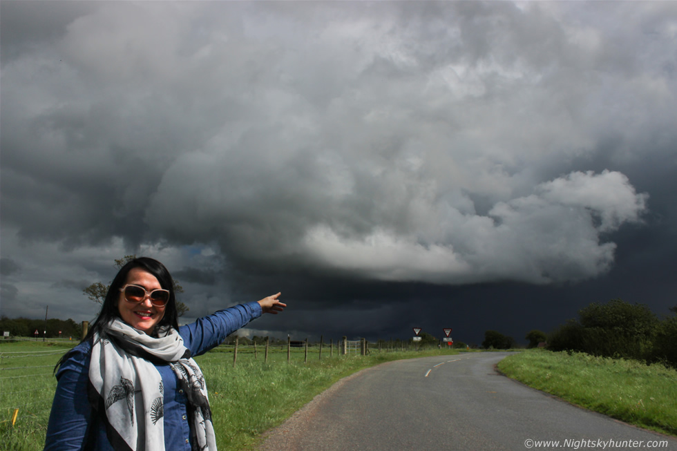 |
We chased it N back down the carriageway then pulled into a side road and got the car parked near a gate. We had used this road before back in 2013 to shoot Noctilucent Clouds (NLCs) so we were familiar with it and just as glad we had made the decision to stop again as it was a nice quiet location with an open view to the E. We where back out shooting the storm and taking video, here's Roisin enjoying the adventure and pointing to the storm, the base and core really was that dark so the clouds were very dramatic and low for photography, to heck with high based storms, I love these surface based storms any day for photogenic structure, even pulse cells can put on a pose for the camera. The dark core is the base of the distant storm over Lough Neagh (same one in the three images above) and in the foreground is a new tower which just went up on the W side of the storm which was now becoming a striking sight.
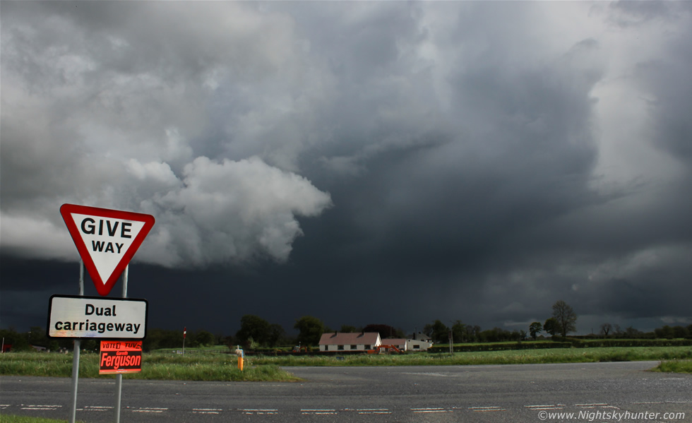 |
I ran back to the junction beside the carriageway to shoot the storm over the main road, I really liked this image of the mean clouds over the 'Give Way' sign - give way to the storm!. Convection was going up all around us to the W, N, and SW and at times it was difficult to look at any one place for any length of time, we were constantly watching and commenting on the convection while monitoring dark bases for funnels.
 |
We took a break and got the flask out and made two cups of tea with a snack, this was heaven for me, sipping a brew with the warm sun on my face with storm clouds all around me surrounded by the scent of fresh fields, thinking about it now makes me smile.
 |
Wide angle as the storm slowly drifted off in the direction of Lough Neagh with new updraught growing higher by the second. There was a mass of complex convection to our N so we decided to keep going in that direction towards it.
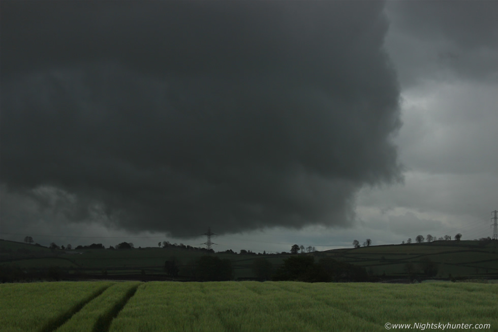 |
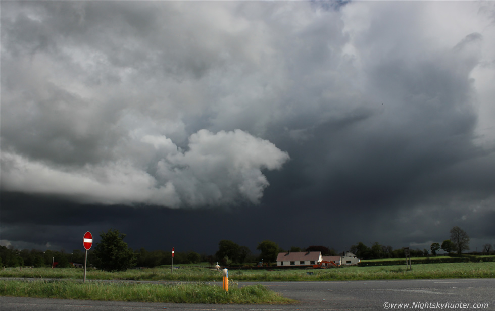
The wind had veered to a NWly so all the cells where going SE now. While on the road we entered the core of heavy showers and once we punched through some bad visibility gunge we emerged out the back end of it to be greeted to another dramatic sight in the form of a massive wall of black clouds hugging the field very close to the ground, the roads were narrow and busy so we took the next chance we had to get off and ended up in a small car park beside a church and graveyard outside Desertmartin. We watched as the rain rattled off the windscreen and I quickly got sick waiting for it to stop so I got out and crossed the road and began taking images while making good use of a fence post to support the camera. This was quite a cool sight over the fields with tractor lines and there was a lot of good motion going on generated by outflow forces. This was actually one side of a large gust front/shelf cloud feature which was growing on the leading edge of this very big cell cluster, moving L to R, you can see the precip to the L, I deliberately exposed the image to show how dark it looked at the time so this is quite close to reality.
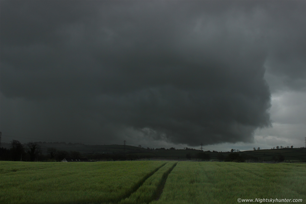 |
Raining away here, my camera was getting soaked in sec's and so was I because I was just in a t-shirt, big rain drops splashed on the lens and one made it into the glass, I had to keep rubbing it with a cloth every 30 sec's or so. You can see the precip from this growing storm, the leaded edge extended off to the L and over my head into the W, this was big and mean looking however it wasn't electrified however unknown to us at the time we were actually witnessing the birth of the main storm of the day which would later move into Co. Down producing intense rainfall and lightning during the late evening hours with red echoes on radar, at least we where under it while it was getting into gear and evolving into a meaner cell. We took shelter back in the car and heavy rain forced the wipers into high speed in order to see anything at all, the scud on the leading edge of the gust front area was impressive to watch, large formations of ropey scud would get lifted from near ground level and forced upwards into the air where it merged with the larger cloud mass, you could actually see the effect of downdraught undercutting the warmer air ahead and trigger this mechanism which can be seen on the video, following this we observed very slow rotation associated with this outflow interaction then moved back N to get behind it.
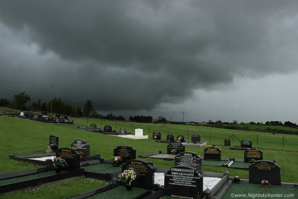 |
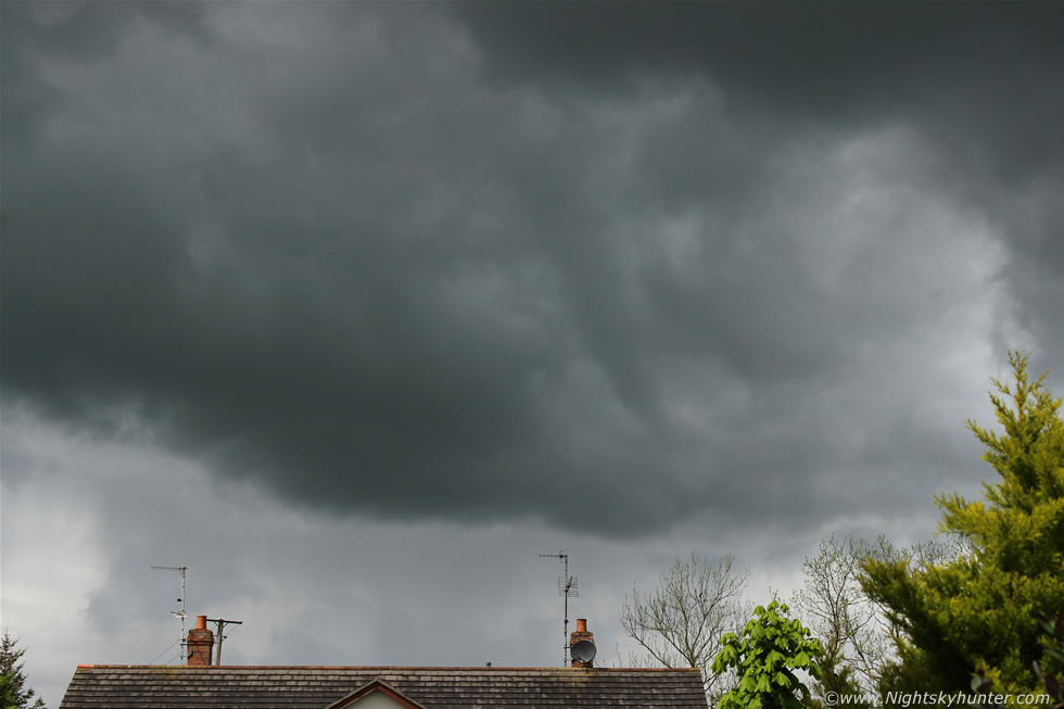
Once we emerged out of the rain we saw a stunning black base at the back of that cluster, it looked like there was some sort of back-building going on and the base itself was black and almost hugging the ground with dark precip core dumping rain over the fields for miles into the distance, we were shocked at how big this had grown and by how impressive the base was, we needed images however trees and houses afforded us only brief glimpses so we passed through Tobermore and stopped beside the church at the end of town on high ground for a last look at that base. The scene was quite cool with this HP storm and base looming over the landscape as it slowly crept away from us against the eerie foreground of the graveyard, this was the back end of the storm which would produce active sparks over Banbridge and beyond later. We headed back to Maghera where we ended the chase, all the good stuff had moved too far SE so we called it a day feeling content with the days catch. It was a fun road trip and exciting with dramatic cloudscapes which made the day a complete success and in addition to this my forecast was also close to the mark as well so it was a positive and fun day all round, we celebrated later with a nice meal out and on the way home at sunset I was shocked to see big dark towers over the Sperrins, they didn't spark however the sight alone was a nice way to end the day.
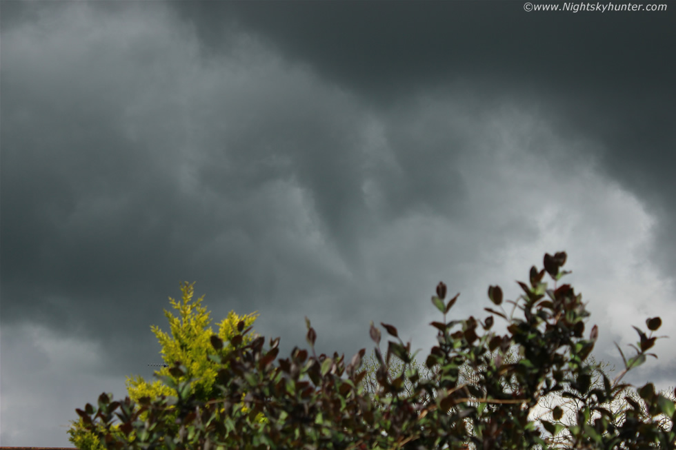 |
May 13th turned into an exciting day. There really wasn't much of a chance of thunderstorms in N. Ireland (there were a few sparks in the SE) due to low end instability with 200-400 CAPE with the former over my area of Maghera during the morning so I was not excited about the potential, however from early morning I couldn't help shake a gut instinct I had about the prospect of funnel clouds this day, in fact, I even had it in mind since the previous night so I trusted my intuition and kept a very close eye on the sky from early morning onwards. The NWly flow was slack which was always good for funnel chances and with strong solar heating I knew convection was more likely to fire with greater potential despite the restrictive CAPE. It was a fantastic morning, very warm with intense sunshine which got convection going readily, I really should have been doing other things however I just couldn't take my eyes from the sky so I set up my laptop in the kitchen and checked the radar while heading out into the backyard every ten min's or so. My casual glances soon changed to more focused surveillance when I watched two large towers come to life in a fashion which I hadn't seen this year to date, from what seemed like nothing these two updraughts absolutely 'exploded' upward in an instant from an insignificant cumulus into crisp boiling towers of energy which looked like the result of several thousand CAPE unleashed and not the product of what the models indicated, the updraughts were so strong I was stunned and climbed on top of the oil tank to get a better view over the garden fence as they towered high into the sky. I posted about this on facebook and twitter then got my camera ready because the next episode of real time boiling convection like that deserved to be filmed on a tripod which would make for an awesome time lapse clip, so that was the plan anyway, I was on full alert.
At 12.55 I was on my lap top when I sensed something was going to happen so I walked into the backyard and glanced to the NW and rite before my eyes was a funnel cloud forming from a very impressive black base below a new updraught which had slowly sailed in, I grabbed the camera and began shooting still images and video as I watched the funnel evolve over the next few min's. It began as a twirling loose scud fragment which began to slowly wrap up and soon it was spinning in a very obvious way to the naked eye which was exciting to watch, the funnel was black with a periodic cloud collar and at times it could be seen dragging cloud fragments around with it, the funnel waxed and waned in form and grew longer as it neared with a transparent condensation funnel at the bottom. Below are a selection of the many images taken during its most photogenic phase.
 |
The funnel was very close, probably over the W side of the Coleraine road and no doubt spinning over the road itself at one point. It was difficult to get good foreground with just min's to be creative so I quickly used the tree tops in our garden, the neighbour's roof made for a good sense of scale. It was a challenge to take images and video footage with the same camera however I did the best I could. The entire frame is filled with the base of the updraught, I was directly under it and the funnel was spinning in the middle while crisp white updraught towers shone in the sun rite above me casting their shadows onto the grass.
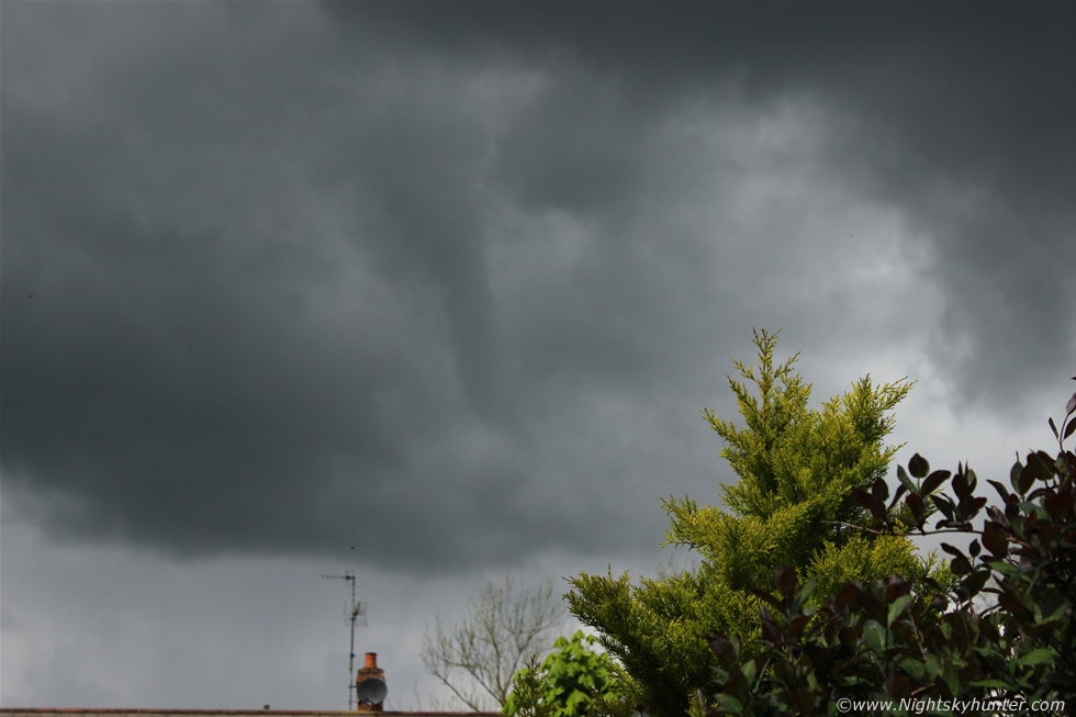 |
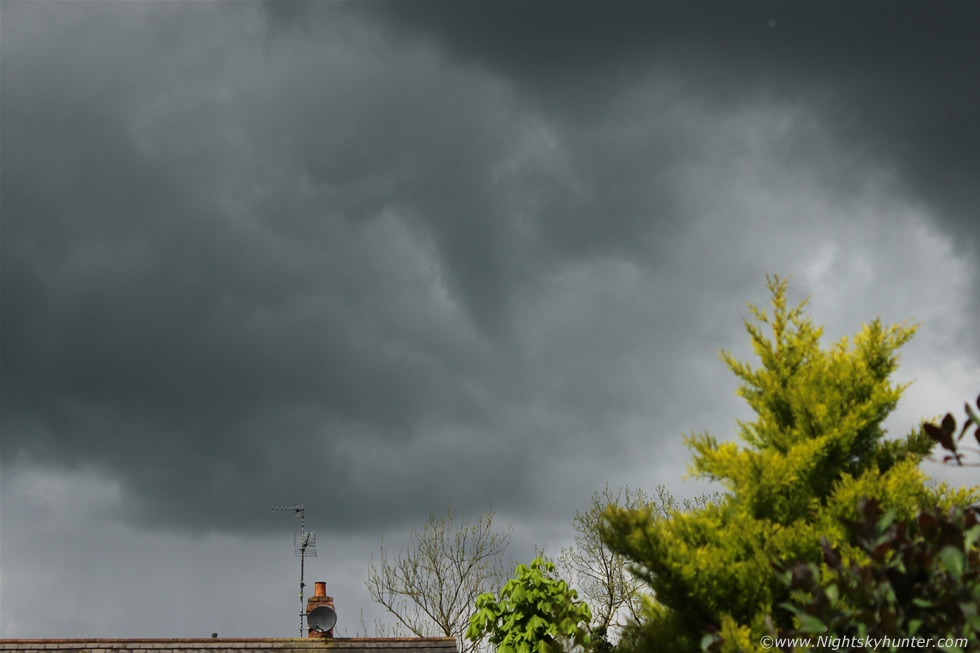
It began to Get longer in shape while bending slightly at the lower end. Local convergence was probably the cause of this brief spin up, either from differential heating or even the effects of the flow over the local terrain itself, perhaps the Sperrins had a roll to play in it as they have done so numerous times in the past.
 |
It looked really cool at this stage over the house with a long and slender dark tube. I suspect the funnel was much longer than it seems here as its base cannot be seen so it likely formed higher up and was hidden from view in the cloud. It felt thrilling to watch because this was my first funnel catch of the 2014 season, however it felt more personal than that, I have been doing a lot of chasing since late April until the present with a decent amount of miles, time, and money spent hunting for cool weather scenes like this, then on the day that looks least promising I get a funnel beside my home, I mean I was literally standing in my backyard taking these, so it felt like the funnel had come to me, perhaps nature was giving me a treat for all the recent effort, this is what I like to believe anyway.
 |
Had this been visible against a clear blue sky background rather than cloud then this would have been an awesome photo opp, however I ain' t complaining and felt grateful to experience this at close range even if it was only a weak vortex. After this shot it began to shrink in size and withdraw into the base and it was gone, however I called my Mother out just in time for her to witness the last stages of its life.
Full video blog of our May 13th storm chase in the Cookstown area featuring the build up with me discussing the forecast potential then moving on to Roisin and I on the road making regular stops to film convection and show how the day developed with the highlights being the Cookstown cell/convection and of course the gust front pulling scud rapidly upwards.
HD video clip of the funnel cloud with a section near the end featuring the funnel at x4 and x8 speed to show the rotation more clearly. Talk about a nice treat!, the rest of the day was a visual feast of beautiful towers and black bases, I had my eyes glued to the skies all day in case there were more funnels, some really photogenic updraughts were at work with several stunning bases observed in the Cookstown area by late afternoon. My plan is to shoot a very large and extremely photogenic funnel cloud or tornado in N. Ireland over a sunlit field or open road and I will be doing my best to make this goal happen over the next few months, now to get back looking at the models to see when the next chance of storms will be - thanks very much for reading.
Martin McKenna